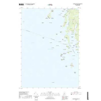
2018 Map of Leadbetter Island
USGS Topo · Published 2018About this map
Leadbetter Island and its surrounding archipelago define this maritime landscape in Penobscot Bay. The map documents the intricate navigation routes of the Knox County coastline, most notably the E. Frank Thompson Ferry line crossing from the west toward Lawrys Narrows. On the larger landmasses, a network of local roads such as Browns Head Light Rd and Wharf Quarry Rd suggests a history of coastal industry and lighthouse access. The interior terrain features prominent heights like Tiptoe Mtn and Mid Mtn, while the coastline is a complex maze of coves and ledges, including Wooster Cove and the treacherous-sounding Drunkard Ledge. This survey provides a modern record of the shoreline and small island clusters such as Fiddlehead Island and Dogfish Island before shifting tides or coastal development alter the seafaring character of the region.
Find a feature on this map
81 named features on this map. Tap any name to fly to it.
Don’t see what you’re looking for? This feature index may not catch every label — zoom into the map to look around manually.
Map Details
Editions of this 2018 Leadbetter Island Map
This is the sole edition of this map. No revisions or reprints were ever made.
Other maps of this area

1904 · Vinalhaven
USGS Topo · 1:62,500

1904 · Tenants Harbor
USGS Topo · 1:62,500

1904 · Rockland
USGS Topo · 1:62,500

1905 · Penobscot Bay
USGS Topo · 1:125,000

1906 · Matinicus
USGS Topo · 1:62,500

1906 · Tennant Harbor
USGS Topo · 1:62,500

1906 · Rockland
USGS Topo · 1:62,500

1941 · Rockland
USGS Topo · 1:62,500

1941 · Vinalhaven
USGS Topo · 1:62,500

1944 · Vinalhaven
USGS Topo · 1:62,500