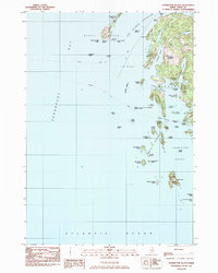
1982 Map of Leadbetter Island
USGS Topo · Published 1983About this map
Penobscot Bay surrounds a complex archipelago of the Fox Islands in the early 1980s, where the maritime boundaries of North Haven and Vinalhaven meet. The map details a landscape defined by granite and water, featuring topographical landmarks like Tiptoe Mountain and Middle Mountain alongside numerous ledges such as Crabtree Point Ledge and Fiddlers Ledge. Coastal navigation is supported by the Lighthouse at Browns Head and the Dog Fish Beacon, guiding vessels through the Fox Islands Thorofare and the narrow passages of Leadbetter Narrows. Local industry and conservation are noted through the presence of a Gravel Pit and a Quarry on Vinalhaven, while the Green Island Wildlife Management Area and the Outward Bound Sch on Hurricane Island reflect the era's focus on environmental stewardship and outdoor education.
Find a feature on this map
69 named features on this map. Tap any name to fly to it.
Don’t see what you’re looking for? This feature index may not catch every label — zoom into the map to look around manually.
Map Details
Editions of this 1982 Leadbetter Island Map
This is the sole edition of this map. No revisions or reprints were ever made.
Other maps of this area

1904 · Vinalhaven
USGS Topo · 1:62,500

1904 · Tenants Harbor
USGS Topo · 1:62,500

1904 · Rockland
USGS Topo · 1:62,500

1905 · Penobscot Bay
USGS Topo · 1:125,000

1906 · Matinicus
USGS Topo · 1:62,500

1906 · Tennant Harbor
USGS Topo · 1:62,500

1906 · Rockland
USGS Topo · 1:62,500

1941 · Rockland
USGS Topo · 1:62,500

1941 · Vinalhaven
USGS Topo · 1:62,500

1944 · Vinalhaven
USGS Topo · 1:62,500