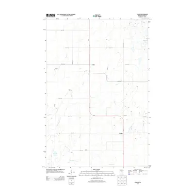
2013 Map of Leader
USGS Topo · Published 2013About this map
Poplar and the surrounding Cass County countryside are defined by a network of creeks and small glacial lakes within a rural landscape. The settlement of Poplar serves as a central point in this northern Minnesota survey, supported by the historic Poplar Cem and the southern communities of Leader and Ellis. The geography is intricately carved by several waterways, including the winding paths of Martin Cr, Tower Cr, and Swan Cr, which drain into localized basins like Hardwood Lake and Mud Lake. A grid of county and township roads, such as Hulett Rd and Township Rd, provides access to these remote homesteads and agricultural tracts. This detailed map captures the intersection of MN-64 and Co Hwy-24, illustrating the infrastructure that connects these isolated settlements in a landscape dominated by riparian corridors and dense wetlands.
Find a feature on this map
30 named features on this map. Tap any name to fly to it.
Don’t see what you’re looking for? This feature index may not catch every label — zoom into the map to look around manually.
Map Details
Editions of this 2013 Leader Map
This is the sole edition of this map. No revisions or reprints were ever made.
Other maps of this area

1919 · Leader
USGS Topo · 1:62,500

1953 · Brainerd
USGS Topo · 1:250,000

1957 · Brainerd
USGS Topo · 1:250,000

1958 · Brainerd
USGS Topo · 1:250,000

1965 · Brainerd
USGS Topo · 1:250,000

1966 · Staples NE
USGS Topo · 1:24,000
1966 · Casino
USGS Topo · 1:24,000
1966 · Motley NW
USGS Topo · 1:24,000

1969 · Burgen Lake
USGS Topo · 1:24,000
1969 · Oylen
USGS Topo · 1:24,000