
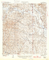
1943 Map of Leander
USGS Topo · Published 1943About this map
The Kisatchie National Forest dominates much of this landscape, which was recorded just as the area was being transformed by military activity. In the southern portion of the sheet, the legacy of the timber industry is visible through the Old Logging Railroad and Old Logging Grade networks that once connected the company towns of Fullerton and East Fullerton. These settlements, alongside Hicks and Lacamp, were integral to the regional economy before the expansion of military reservations during the early 1940s.
Find a feature on this map
61 named features on this map. Tap any name to fly to it.
Don’t see what you’re looking for? This feature index may not catch every label — zoom into the map to look around manually.
Map Details
Editions of this 1943 Leander Map
2 editions found
Other maps of this area

1932 · Boyce SW
USGS Topo · 1:31,680

1935 · Pawnee
USGS Topo · 1:31,680

1937 · Chopin SW
USGS Topo · 1:31,680

1937 · Chopin SE
USGS Topo · 1:31,680

1941 · Slagle
USGS Topo · 1:62,500

1941 · Boyce
USGS Topo · 1:62,500

1942 · Kisatchie
USGS Topo · 1:62,500

1942 · Oakdale
USGS Topo · 1:62,500

1943 · Kisatchie
USGS Topo · 1:62,500

1944 · Chopin
USGS Topo · 1:62,500