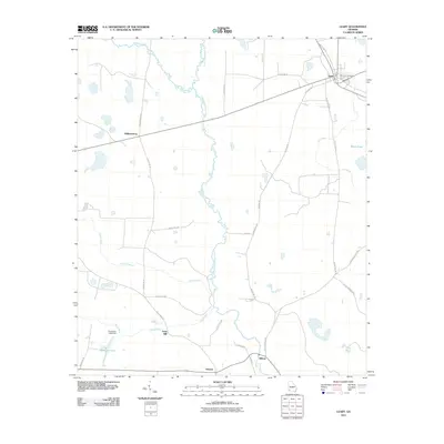
2011 Map of Leary
USGS Topo · Published 2011About this map
Leary serves as a primary hub for this southwestern Georgia landscape, where agricultural fields are intersected by the winding course of Ichawaynochaway Creek. The settlement pattern follows a grid of rural routes including Milford RD and Old Milford RD, connecting smaller locales like Milford, Williamsburg, and Patmos. Water management and local industry are evidenced by features such as the Thompson Lake Dam and Iveys Mill, which sits along Mill Creek. To the northeast, the Leary City Cemetery provides a focal point for genealogical interest near the town center. The terrain is defined by a network of drainage ways including Pachitla Creek, Caney Creek, and Keel Creek, which feed into larger bodies like Thompson Lake and White Pond, illustrating the hydraulic character of the coastal plain during this era.
Find a feature on this map
36 named features on this map. Tap any name to fly to it.
Don’t see what you’re looking for? This feature index may not catch every label — zoom into the map to look around manually.
Map Details
Editions of this 2011 Leary Map
This is the sole edition of this map. No revisions or reprints were ever made.
Other maps of this area

1953 · Dothan
USGS Topo · 1:250,000

1954 · Dothan
USGS Topo · 1:250,000

1955 · Dothan
USGS Topo · 1:250,000

1956 · Newton
USGS Topo · 1:62,500

1956 · Sasser
USGS Topo · 1:62,500

1973 · Morgan
USGS Topo · 1:24,000
1973 · Holt
USGS Topo · 1:24,000

1973 · Edison
USGS Topo · 1:24,000

1974 · Damascus
USGS Topo · 1:24,000

1974 · Arlington
USGS Topo · 1:24,000