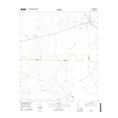
2014 Map of Leary
USGS Topo · Published 2014About this map
Ichawaynochaway Creek serves as the primary drainage for this agricultural landscape on the border of Calhoun and Baker counties. The settlement of Leary anchors the northeast corner, where a grid of local streets like N Depot St and S Depot St suggest a history tied to transportation and trade. To the south, small communities and named locales such as Patmos, Milford, and Iveys Mill are connected by a network of rural routes including Ga-216 and Julia Jones Rd.
Find a feature on this map
48 named features on this map. Tap any name to fly to it.
Don’t see what you’re looking for? This feature index may not catch every label — zoom into the map to look around manually.
Map Details
Editions of this 2014 Leary Map
This is the sole edition of this map. No revisions or reprints were ever made.
Other maps of this area

1953 · Dothan
USGS Topo · 1:250,000

1954 · Dothan
USGS Topo · 1:250,000

1955 · Dothan
USGS Topo · 1:250,000

1956 · Newton
USGS Topo · 1:62,500

1956 · Sasser
USGS Topo · 1:62,500

1973 · Morgan
USGS Topo · 1:24,000
1973 · Holt
USGS Topo · 1:24,000

1973 · Edison
USGS Topo · 1:24,000

1974 · Damascus
USGS Topo · 1:24,000

1974 · Arlington
USGS Topo · 1:24,000