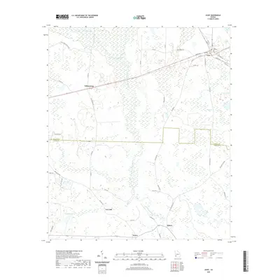
2020 Map of Leary
USGS Topo · Published 2020About this map
Pachitla Creek and Ichawaynochaway Creek dominate the drainage patterns of this southwest Georgia landscape, where the town of Leary sits as a primary junction for local travel. The terrain is marked by numerous wetlands and small water bodies such as White Pond and Thompson Lake, reflecting the low-lying nature of the Gulf Coastal Plain. Small community clusters and points of historical interest, including Williamsburg, Milford, and Patmos, are connected by a network of county roads that traverse the boundary between Calhoun and Baker counties. The presence of Tveys Mill and the Leary City Cem provides specific points for genealogical research, while the surrounding roads like Caney Creek Plantation Rd and Old Leary Rd suggest a long history of agricultural land use and plantation-era spatial organization.
Find a feature on this map
51 named features on this map. Tap any name to fly to it.
Don’t see what you’re looking for? This feature index may not catch every label — zoom into the map to look around manually.
Map Details
Editions of this 2020 Leary Map
This is the sole edition of this map. No revisions or reprints were ever made.
Other maps of this area

1953 · Dothan
USGS Topo · 1:250,000

1954 · Dothan
USGS Topo · 1:250,000

1955 · Dothan
USGS Topo · 1:250,000

1956 · Newton
USGS Topo · 1:62,500

1956 · Sasser
USGS Topo · 1:62,500

1973 · Morgan
USGS Topo · 1:24,000
1973 · Holt
USGS Topo · 1:24,000

1973 · Edison
USGS Topo · 1:24,000

1974 · Damascus
USGS Topo · 1:24,000

1974 · Arlington
USGS Topo · 1:24,000