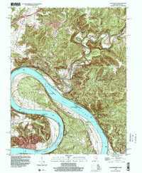
1998 Map of Leavenworth
USGS Topo · Published 2001About this map
The Ohio River dominates this landscape as it carves massive, sweeping loops known as Big Bend and Oxbow Bend along the Indiana and Kentucky border. This late 1990s record of the region shows the distinction between the contemporary settlement of Leavenworth and Old Leavenworth, reflecting the community's movement away from the river’s floodplain. Significant portions of the rugged, wooded upland are protected within the Harrison-Crawford State Forest, where the Blue River snakes southward to join the Ohio near Blue River Island.
Find a feature on this map
35 named features on this map. Tap any name to fly to it.
Don’t see what you’re looking for? This feature index may not catch every label — zoom into the map to look around manually.
Map Details
Editions of this 1998 Leavenworth Map
This is the sole edition of this map. No revisions or reprints were ever made.
Other maps of this area

1931 · Corydon
USGS Topo · 1:62,500

1944 · Corydon West
USGS Topo · 1:24,000

1946 · Leavenworth
USGS Topo · 1:24,000

1946 · Depauw
USGS Topo · 1:24,000

1947 · Leavenworth
USGS Topo · 1:24,000

1947 · Corydon West
USGS Topo · 1:24,000

1947 · Mauckport
USGS Topo · 1:24,000

1948 · Milltown
USGS Topo · 1:24,000

1950 · Beechwood
USGS Topo · 1:24,000

1950 · English
USGS Topo · 1:24,000