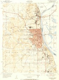
1951 Map of Leavenworth
USGS Topo · Published 1951About this map
The Fort Leavenworth Military Reservation and the city of Leavenworth anchor this 1951 study of the Missouri River bank. The landscape is defined by institutional land use, showing the massive Federal Penitentiary and the Sherman Air Force Base positioned north of the city center. This era shows a dense concentration of medical and educational facilities, including St Marys College, St Johns Hospital, and the Veterans Hospital at Wadsworth.
Find a feature on this map
63 named features on this map. Tap any name to fly to it.
Don’t see what you’re looking for? This feature index may not catch every label — zoom into the map to look around manually.
Map Details
Editions of this 1951 Leavenworth Map
2 editions found
Other maps of this area

1886 · Oskaloosa
USGS Topo · 1:125,000

1888 · Oskaloosa
USGS Topo · 1:125,000

1890 · Kansas City
USGS Topo · 1:125,000

1894 · Kansas City
USGS Topo · 1:125,000

1894 · Oskaloosa
USGS Topo · 1:125,000

1910 · Leavenworth
USGS Topo · 1:62,500

1934 · Bonner Springs
USGS Topo · 1:48,000

1934 · Wolcott
USGS Topo · 1:24,000

1940 · Bonner Springs
USGS Topo · 1:62,500
1948 · Wolcott
USGS Topo · 1:24,000