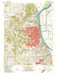
1984 Map of Leavenworth
USGS Topo · Published 1991About this map
Fort Leavenworth Military Reservation and the sprawling correctional facilities of the mid-1980s dominate this landscape along the Missouri River. The urban core of Leavenworth is shown in detail, revealing a dense network of institutions including the Federal Penitentiary, the Disciplinary Barracks, and the VA Hospital. To the south, the community of Lansing sits near the State Penitentiary and the Co Convalescent Infirmary, reflecting the region's long-standing role in military and penal administration.
Find a feature on this map
71 named features on this map. Tap any name to fly to it.
Don’t see what you’re looking for? This feature index may not catch every label — zoom into the map to look around manually.
Map Details
Editions of this 1984 Leavenworth Map
3 editions found
Other maps of this area

1886 · Oskaloosa
USGS Topo · 1:125,000

1888 · Oskaloosa
USGS Topo · 1:125,000

1890 · Kansas City
USGS Topo · 1:125,000

1894 · Kansas City
USGS Topo · 1:125,000

1894 · Oskaloosa
USGS Topo · 1:125,000

1910 · Leavenworth
USGS Topo · 1:62,500

1934 · Bonner Springs
USGS Topo · 1:48,000

1934 · Wolcott
USGS Topo · 1:24,000

1940 · Bonner Springs
USGS Topo · 1:62,500
1948 · Wolcott
USGS Topo · 1:24,000