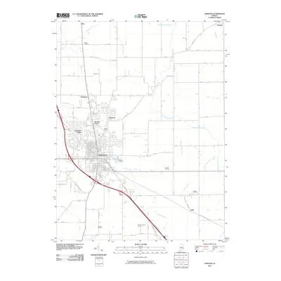
2010 Map of Lebanon
USGS Topo · Published 2010About this map
The city of Lebanon serves as the central hub of this Boone County landscape, showing its transition from a structured urban grid to an expansive suburban and agricultural periphery in the early 21st century. The map details several distinct residential developments such as Ulen, Northfield Village, and Brendan Wood, which cluster around the northern and western edges of the city. Beyond the residential areas, the terrain is defined by a dense network of drainage infrastructure, including Prairie Creek and numerous man-made channels like Buntin Ditch and Storms Ditch, reflecting the region's managed water system. Genealogists will find significant value in the distribution of several historic burial grounds scattered throughout the rural sections, from the large Oak Hill Cemetery to smaller sites like Bethel Cemetery and Dowden Cemetery. The presence of the Boone County Airport and the prominent diagonal of Indianapolis Ave underscore the importance of transportation links to the state capital.
Find a feature on this map
63 named features on this map. Tap any name to fly to it.
Don’t see what you’re looking for? This feature index may not catch every label — zoom into the map to look around manually.
Map Details
Editions of this 2010 Lebanon Map
This is the sole edition of this map. No revisions or reprints were ever made.
Other maps of this area

1953 · Fayette
USGS Topo · 1:24,000

1953 · Rosston
USGS Topo · 1:24,000

1953 · Lizton
USGS Topo · 1:24,000

1953 · Zionsville
USGS Topo · 1:24,000

1953 · Lebanon
USGS Topo · 1:24,000

1953 · Danville
USGS Topo · 1:250,000

1953 · Indianapolis
USGS Topo · 1:250,000

1955 · Danville
USGS Topo · 1:250,000

1956 · Danville
USGS Topo · 1:250,000

1956 · Indianapolis
USGS Topo · 1:250,000