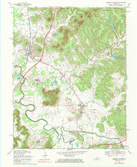
1967 Map of Lebanon Junction
USGS Topo · Published 1983About this map
The Louisville and Nashville railroad serves as the industrial spine of this region, intersecting with the Kentucky Turnpike at the rail-centric hub of Lebanon Junction. To the east, the landscape transitions into the steep, wooded hills of Bernheim Forest, where landmarks like Crutcher Hollow and Scuffletown Hollow mark the rugged topography. The southern portion of the sheet is defined by the convergence of major waterways, specifically the meandering Rolling Fork and Beech Fork, which create a complex drainage pattern including the Rolling Fork Slough. Local community life is anchored by rural institutions such as the Little Brick Sch and several country churches, including Temple Hill Ch and Mt Moriah Ch. Near the settlement of Boston, the terrain levels out into fertile bottomlands where the Blue Grass Parkway begins its eastward sweep.
Find a feature on this map
35 named features on this map. Tap any name to fly to it.
Don’t see what you’re looking for? This feature index may not catch every label — zoom into the map to look around manually.
Map Details
Editions of this 1967 Lebanon Junction Map
This is the sole edition of this map. No revisions or reprints were ever made.
Other maps of this area

1935 · Elizabethtown
USGS Topo · 1:48,000

1936 · Vine Grove
USGS Topo · 1:62,500

1938 · Elizabethtown
USGS Topo · 1:62,500

1943 · Vine Grove
USGS Topo · 1:62,500

1946 · Pitts Point
USGS Topo · 1:24,000

1946 · Colesburg
USGS Topo · 1:24,000

1946 · Vine Grove
USGS Topo · 1:62,500

1949 · Cravens
USGS Topo · 1:24,000

1949 · Elizabethtown
USGS Topo · 1:24,000

1949 · Shepherdsville
USGS Topo · 1:24,000