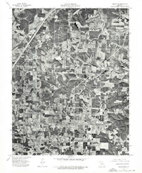
1975 Map of Lebanon NE
USGS Topo · Published 1976About this map
Oakland sits amidst a geometric patchwork of agricultural fields and woodlots in Laclede County, as documented in this 1975 orthophotograph. The aerial perspective reveals a landscape defined by traditional land use, where the winding course of Mill Creek cuts through the more regular patterns of the rural property grid. This photographic record, compiled by the U.S. Geological Survey and the State of Missouri, provides a clear view of the road network and farmstead placement during the mid-1970s. For the local historian or researcher, the orthophoto format captures the literal footprint of the community, showing the exact density of timber and the specific configuration of agricultural clearings surrounding the settlement of Oakland.
Find a feature on this map
2 named features on this map. Tap any name to fly to it.
Don’t see what you’re looking for? This feature index may not catch every label — zoom into the map to look around manually.
Map Details
Editions of this 1975 Lebanon NE Map
This is the sole edition of this map. No revisions or reprints were ever made.
Other maps of this area

1933 · Stoutland
USGS Topo · 1:62,500

1938 · Stoutland
USGS Topo · 1:62,500

1941 · Lebanon
USGS Topo · 1:62,500

1943 · Richland
USGS Topo · 1:62,500

1943 · Lebanon
USGS Topo · 1:62,500

1943 · Drynob
USGS Topo · 1:62,500

1954 · Springfield
USGS Topo · 1:250,000

1954 · Drynob
USGS Topo · 1:62,500
1954 · Richland
USGS Topo · 1:62,500

1954 · Drew
USGS Topo · 1:24,000