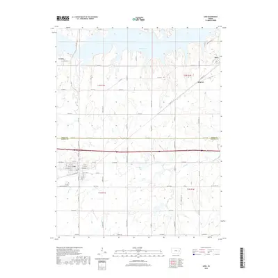
2018 Map of Lebo
USGS Topo · Published 2018About this map
Lebo serves as the primary municipal center in this section of the Kansas plains, situated just south of the Osage and Coffey County line. The town's grid is clearly defined by landmarks such as the Post Office and streets like E Broadway St and E Sac & Fox St. The northern portion of the landscape is dominated by the intricate, branching shoreline of Melvern Lake, which has significantly altered the drainage patterns of local tributaries like Coal Cr. Further east, the small settlement of Olivet sits near the reservoir's edge, while Arvonia remains a named point to the west. The area's rural character is maintained through a network of section-line roads, including Old State Hwy 50, and quiet local landmarks such as Key West Cem located near Frog Creek.
Find a feature on this map
67 named features on this map. Tap any name to fly to it.
Don’t see what you’re looking for? This feature index may not catch every label — zoom into the map to look around manually.
Map Details
Editions of this 2018 Lebo Map
This is the sole edition of this map. No revisions or reprints were ever made.
Other maps of this area

1885 · Burlington
USGS Topo · 1:125,000

1889 · Burlingame
USGS Topo · 1:125,000

1894 · Burlingame
USGS Topo · 1:125,000

1894 · Burlington
USGS Topo · 1:125,000

1947 · Lawrence
USGS Topo · 1:250,000

1950 · Lawrence
USGS Topo · 1:250,000

1956 · Lawrence
USGS Topo · 1:250,000

1957 · Lebo
USGS Topo · 1:24,000

1957 · Waverly NW
USGS Topo · 1:24,000
1957 · Lebo NW
USGS Topo · 1:24,000