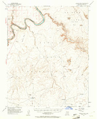
1954 Map of Leche-E Rock
USGS Topo · Published 1961About this map
The Colorado River carves a deep arc through the northwestern corner of this territory, defining the northwestern corner of the Navajo Indian Reservation. Based on 1951 aerial photography, the landscape is a complex network of high plateaus and isolated landforms including Rainbow Plateau and Wild Horse Mesa. Distinctive geological features like Tower Butte, Sentinel Rock, and Leche-e Rock serve as vertical landmarks across the high desert.
Find a feature on this map
29 named features on this map. Tap any name to fly to it.
Don’t see what you’re looking for? This feature index may not catch every label — zoom into the map to look around manually.
Map Details
Editions of this 1954 Leche-E Rock Map
3 editions found

Other maps of this area

1886 · Escalante
USGS Topo · 1:250,000

1886 · Echo Cliffs
USGS Topo · 1:250,000

1891 · Echo Cliffs
USGS Topo · 1:250,000

1922 · Warm Creek
USGS Topo · 1:63,360

1951 · Lees Ferry NE
USGS Topo · 1:24,000

1953 · Cummings Mesa
USGS Topo · 1:62,500

1953 · Nipple Butte
USGS Topo · 1:62,500

1953 · Gunsight Butte
USGS Topo · 1:62,500

1954 · Lees Ferry SE
USGS Topo · 1:24,000

1954 · Tanner Wash
USGS Topo · 1:62,500