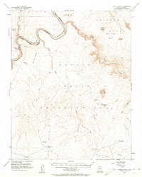
1954 Map of Leche-E Rock
USGS Topo · Published 1961About this map
The Colorado River winds through the high desert of the Navajo Indian Reservation in this mid-century survey. This landscape is defined by its verticality, where the massive Rainbow Plateau and Cummings Mesa rise above deeply incised drainages like Wahweap Creek and Navajo Creek. Before the later development of modern recreation infrastructure, the region was navigated primarily by a network of trails, jeep trails, and pack trails that connected remote water sources such as White Dome Tank, Antelope Tank, and isolated springs. Several prominent survey monuments, including Leche-e Rock and Tower Butte, served as essential landmarks for mapping the Coconino County backcountry. The isolation of features like Nurusse Betay and the sheer verticality of Wall highlight the challenges of transcontinental travel across the Colorado basin during this era.
Find a feature on this map
32 named features on this map. Tap any name to fly to it.
Don’t see what you’re looking for? This feature index may not catch every label — zoom into the map to look around manually.
Map Details
Editions of this 1954 Leche-E Rock Map
3 editions found

Other maps of this area

1886 · Escalante
USGS Topo · 1:250,000

1886 · Echo Cliffs
USGS Topo · 1:250,000

1891 · Echo Cliffs
USGS Topo · 1:250,000

1922 · Warm Creek
USGS Topo · 1:63,360

1951 · Lees Ferry NE
USGS Topo · 1:24,000

1953 · Cummings Mesa
USGS Topo · 1:62,500

1953 · Nipple Butte
USGS Topo · 1:62,500

1953 · Gunsight Butte
USGS Topo · 1:62,500

1954 · Lees Ferry SE
USGS Topo · 1:24,000

1954 · Tanner Wash
USGS Topo · 1:62,500