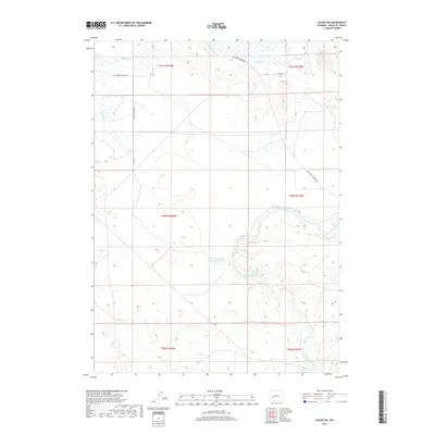
2017 Map of Leckie SW
USGS Topo · Published 2017About this map
The Big Sandy River meanders across the high plains of Sublette County, cutting through a landscape defined by ranch roads and seasonal watercourses. This 2017 survey documents the western edge of the Big Sandy valley, where the Sandy Big Bend Reservoir Number 1 provides a vital water management point in an otherwise arid environment. The network of local routes, including Co Rd 105 and the Big Sandy Elkhorn Rd, provides access to the expansive range land typical of southwestern Wyoming. In the northern reaches, Muddy Cr drains toward the larger river system, tracing a path through the township boundaries of T31N R106W and T31N R105W. The map captures the quiet continuity of this grazing land, reflecting a geography where water resources and isolated road networks like Richie Rd dictate the human footprint on the land.
Find a feature on this map
14 named features on this map. Tap any name to fly to it.
Don’t see what you’re looking for? This feature index may not catch every label — zoom into the map to look around manually.
Map Details
Editions of this 2017 Leckie SW Map
This is the sole edition of this map. No revisions or reprints were ever made.
Other maps of this area

1955 · Lander
USGS Topo · 1:250,000

1958 · Lander
USGS Topo · 1:250,000

1961 · Lander
USGS Topo · 1:250,000

1964 · Fremont Butte
USGS Topo · 1:24,000
1964 · Square Top
USGS Topo · 1:24,000

1969 · Pocket Creek Lake
USGS Topo · 1:24,000

1969 · Leckie Reservoir
USGS Topo · 1:24,000

1969 · Leckie SW
USGS Topo · 1:24,000
1969 · Bull Draw
USGS Topo · 1:24,000

1969 · Tabernacle Butte
USGS Topo · 1:24,000