
1969 Map of Leckie SW
USGS Topo · Published 1973About this map
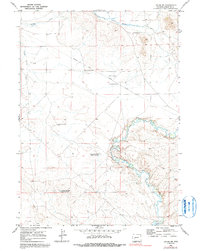
The Emigrant Trail (Lander Cutoff) cuts across this high-desert landscape in Sublette County, tracing a vital historical path for westward migration. This 1969 field survey documents the rugged geography of the western slope, where the Big Sandy River meanders through deep bends in the southeastern corner. The map highlights the intersection of overland travel history and twentieth-century water management, featuring both Historical Monuments along the old trail and infrastructure like Sandy Big Bend Reservoir No 1 and Sandy Big Bend Reservoir No 2. Further north, Muddy Creek and South Muddy Creek drain the open terrain, punctuated only by isolated landmarks such as Sandy Flat Well and the Boundary Line Well.
Find a feature on this map
12 named features on this map. Tap any name to fly to it.
Don’t see what you’re looking for? This feature index may not catch every label — zoom into the map to look around manually.
Map Details
Editions of this 1969 Leckie SW Map
2 editions found
Other maps of this area

1955 · Lander
USGS Topo · 1:250,000

1958 · Lander
USGS Topo · 1:250,000

1961 · Lander
USGS Topo · 1:250,000

1964 · Fremont Butte
USGS Topo · 1:24,000
1964 · Square Top
USGS Topo · 1:24,000

1969 · Pocket Creek Lake
USGS Topo · 1:24,000

1969 · Leckie Reservoir
USGS Topo · 1:24,000
1969 · Bull Draw
USGS Topo · 1:24,000

1969 · Tabernacle Butte
USGS Topo · 1:24,000
1969 · Big Sandy Opening
USGS Topo · 1:24,000