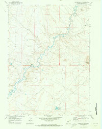
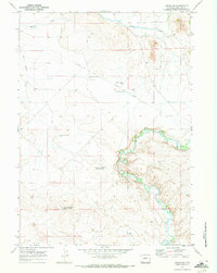
1969 Map of Tabernacle Butte
USGS Topo · Published 1973About this map
The Big Sandy River defines the landscape of this Sublette County region, winding through a complex network of dry draws and desert terrain as it appeared in the late 1960s. The map highlights the sparse but critical water management in this arid high-country environment, notably at Poston Reservoir and various isolated Flowing Wells. Human activity is concentrated around the Scramouspe Ranch, located near the convergence of Water Hole Draw and the river. Significant elevation landmarks include the prominent Tabernacle Butte in the east and Pencil Point to the north, which serve as natural Navigational beacons for the area. The map also meticulously traces livestock boundaries with fine red dashed lines indicating fence lines, reflecting the importance of open-range grazing and ranching boundaries during this period.
Find a feature on this map
11 named features on this map. Tap any name to fly to it.
Don’t see what you’re looking for? This feature index may not catch every label — zoom into the map to look around manually.
Map Details
Editions of this 1969 Tabernacle Butte Map
This is the sole edition of this map. No revisions or reprints were ever made.
Other maps of this area

1955 · Lander
USGS Topo · 1:250,000

1958 · Lander
USGS Topo · 1:250,000

1961 · Lander
USGS Topo · 1:250,000
1964 · Square Top
USGS Topo · 1:24,000
1969 · Juel Spring
USGS Topo · 1:24,000
1969 · Leckie Reservoir
USGS Topo · 1:24,000
1969 · Leckie SW
USGS Topo · 1:24,000
1969 · Bull Draw
USGS Topo · 1:24,000
1969 · Big Sandy Reservoir SE
USGS Topo · 1:24,000
1969 · Big Sandy Reservoir
USGS Topo · 1:24,000