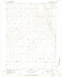
1969 Map of Juel Spring
USGS Topo · Published 1973About this map
Big Sandy River meanders through the eastern edge of this high-desert landscape in the late 1960s, providing a vital water source in a region dominated by ephemeral drainages like Jonah Gulch. The terrain is characterized by the broad expanse of Sublettes Flat, which stretches across the southern portion of the quadrangle near the Sublette Co Sweetwater Co line. Human activity is sparse and primarily tied to livestock and resource extraction, evidenced by a Corral near the center of the map and a Gravel Pit further north. This period shows a Reliance on specific water points for range management, such as North Sublette Meadow Spring, Juel Spring, and the small Juel Reservoir, all connected by a network of unimproved tracks and a Jeep Trail.
Find a feature on this map
11 named features on this map. Tap any name to fly to it.
Don’t see what you’re looking for? This feature index may not catch every label — zoom into the map to look around manually.
Map Details
Editions of this 1969 Juel Spring Map
2 editions found
Other maps of this area

1955 · Lander
USGS Topo · 1:250,000

1958 · Lander
USGS Topo · 1:250,000

1961 · Lander
USGS Topo · 1:250,000

1968 · Twelvemile Knoll
USGS Topo · 1:24,000
1968 · Eden Reservoir West
USGS Topo · 1:24,000
1968 · Fourmile Knoll
USGS Topo · 1:24,000
1969 · Teakettle Butte
USGS Topo · 1:24,000
1969 · Bull Draw
USGS Topo · 1:24,000

1969 · Tabernacle Butte
USGS Topo · 1:24,000
1969 · Big Sandy Reservoir
USGS Topo · 1:24,000