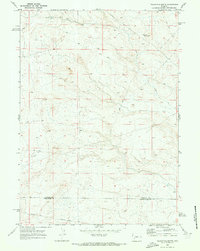
1969 Map of Teakettle Butte
USGS Topo · Published 1973About this map
Teakettle Butte stands as a prominent landmark in this high-desert landscape, located near the boundary where Sublette Co and Sweetwater Co meet. The 1969 field survey documents a terrain defined more by historical movement than permanent settlement, specifically through the passage of the Emigrant Trail. This section of the historic route includes the Sublette Cutoff, a vital path for pioneers seeking a more direct way west. The map also records the utilitarian presence of a Well and several Jeep Trails, indicating the era's continued use of the land for ranching or resource exploration while preserving the physical tracks of nineteenth-century western migration across the Wyoming plains.
Find a feature on this map
6 named features on this map. Tap any name to fly to it.
Don’t see what you’re looking for? This feature index may not catch every label — zoom into the map to look around manually.
Map Details
Editions of this 1969 Teakettle Butte Map
This is the sole edition of this map. No revisions or reprints were ever made.
Other maps of this area

1955 · Lander
USGS Topo · 1:250,000

1958 · Lander
USGS Topo · 1:250,000

1961 · Lander
USGS Topo · 1:250,000

1968 · Twelvemile Knoll
USGS Topo · 1:24,000
1968 · Monument Butte NE
USGS Topo · 1:24,000
1968 · Fourmile Knoll
USGS Topo · 1:24,000
1969 · Sugar Loaf
USGS Topo · 1:24,000
1969 · Juel Spring
USGS Topo · 1:24,000
1969 · Bull Draw
USGS Topo · 1:24,000
1969 · Sugar Loaf NE
USGS Topo · 1:24,000