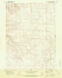
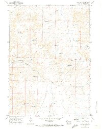
1969 Map of Sugar Loaf NE
USGS Topo · Published 1973About this map
The arid high plains of Sublette County appear here as a landscape defined by water management and resource extraction in the late 1960s. The topography is dominated by the prominent Yellow Point Ridge in the southeast, while the rest of the quadrangle is etched by seasonal watercourses like Alkali Creek and Sand Draw. Man-made intervention is evident in the network of reservoirs and wells necessary for survival and industry in this dry environment, including Wardell Reservoir, Antelope Reservoir No 1, and the Luman Reservoir No 2. This survey also documents the primitive transportation network of the era, marked by a Jeep Trail and remote outposts like the Burma Road Well, reflecting a period when the region was primarily utilized for ranching and early energy exploration.
Find a feature on this map
14 named features on this map. Tap any name to fly to it.
Don’t see what you’re looking for? This feature index may not catch every label — zoom into the map to look around manually.
Map Details
Editions of this 1969 Sugar Loaf NE Map
This is the sole edition of this map. No revisions or reprints were ever made.
Other maps of this area

1955 · Lander
USGS Topo · 1:250,000

1958 · Lander
USGS Topo · 1:250,000

1961 · Lander
USGS Topo · 1:250,000

1964 · Ross Butte
USGS Topo · 1:24,000
1964 · Olsen Ranch
USGS Topo · 1:24,000

1969 · Oasis Well
USGS Topo · 1:24,000
1969 · Sugar Loaf
USGS Topo · 1:24,000
1969 · Teakettle Butte
USGS Topo · 1:24,000
1969 · Sugar Loaf NW
USGS Topo · 1:24,000
1969 · Stud Horse Butte
USGS Topo · 1:24,000