1969 Map of Sugar Loaf NW
USGS Topo · Published 1973About this map
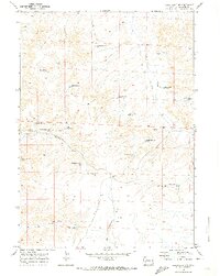
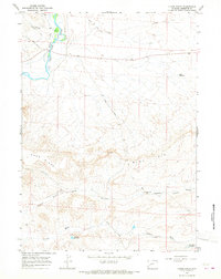
Luman Reservoir No 1 and a network of named livestock or irrigation catchments define this high-desert landscape in Sublette County during the late 1960s. The terrain is characterized by a complex system of dry washes and canyons, most notably Reardon Draw, Buckhorn Draw, and the deep incision of Chapel Canyon to the south. These features reveal an arid environment where water management was paramount, evidenced by the series of numbered basins including Wardell Reservoir No 1, Reardon Reservoir No 1, and Antelope Reservoir No 7. Small-scale surface mining is also present, with several gravel or borrow pits such as Reardon Pit and Alkali Draw Pit No 1 scattered across the township. Primitive transportation routes, mostly designated as jeep trails, connect these remote water and mineral sites, illustrating the land's utility for ranching and resource extraction.
Find a feature on this map
35 named features on this map. Tap any name to fly to it.
Don’t see what you’re looking for? This feature index may not catch every label — zoom into the map to look around manually.
Map Details
Editions of this 1969 Sugar Loaf NW Map
This is the sole edition of this map. No revisions or reprints were ever made.
Other maps of this area
1939 · Big Piney
USGS Topo · 1:125,000
1942 · Big Piney
USGS Topo · 1:125,000

1955 · Preston
USGS Topo · 1:250,000

1955 · Lander
USGS Topo · 1:250,000

1958 · Lander
USGS Topo · 1:250,000

1958 · Preston
USGS Topo · 1:250,000

1961 · Lander
USGS Topo · 1:250,000

1962 · Preston
USGS Topo · 1:250,000
1964 · Ross Butte
USGS Topo · 1:24,000
1964 · Olsen Ranch
USGS Topo · 1:24,000