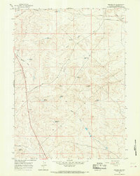
1964 Map of Square Top
USGS Topo · Published 1968About this map
The Emigrant Trail traverses the northern edge of this high-altitude landscape, marking a historic corridor through the sagebrush and arid hills of Sublette County. Recorded in the mid-1960s, this area is defined by its vital water management for ranching and livestock, evidenced by scattered catchments like Desert Res No 1, Mayo Reservoir, and Tibbals Reservoir. The topography is shaped by the drainage systems of Muddy Creek and South Muddy Creek, which cut through the high ground near the prominent Square Top rise.
Find a feature on this map
20 named features on this map. Tap any name to fly to it.
Don’t see what you’re looking for? This feature index may not catch every label — zoom into the map to look around manually.
Map Details
Editions of this 1964 Square Top Map
2 editions found
Other maps of this area

1955 · Lander
USGS Topo · 1:250,000

1958 · Lander
USGS Topo · 1:250,000

1961 · Lander
USGS Topo · 1:250,000

1964 · Fremont Butte
USGS Topo · 1:24,000

1964 · Boulder
USGS Topo · 1:24,000

1969 · Pocket Creek Lake
USGS Topo · 1:24,000

1969 · Leckie SW
USGS Topo · 1:24,000
1969 · Bull Draw
USGS Topo · 1:24,000

1969 · Tabernacle Butte
USGS Topo · 1:24,000
1969 · Stud Horse Butte
USGS Topo · 1:24,000