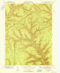
1950 Map of Lee Fire Tower
USGS Topo · Published 1950About this map
Kettle Creek and its many tributaries carve through the borderlands of Abbott, Stewardson, and Brown townships in this 1950 survey. The landscape is defined by its deep drainage patterns and ridges, featuring the namesake Lee Fire Tower standing at a high point near the headwaters of Buck Run. Evidence of the area's resource-driven economy is scattered across the terrain, from a Clay Mine near Daugherty Road to a Gas Well located along Cushman Road. Historical water management is visible at Sliders Dam and Big Dam, while an extensive network of footpaths like the Brackman Trail and Chestnut Trail suggests a rugged interior accessible primarily by trail and forest road. The map also delineates the precise meeting of Potter and Tioga counties within these deeply wooded hollows.
Find a feature on this map
71 named features on this map. Tap any name to fly to it.
Don’t see what you’re looking for? This feature index may not catch every label — zoom into the map to look around manually.
Map Details
Editions of this 1950 Lee Fire Tower Map
This is the sole edition of this map. No revisions or reprints were ever made.
Other maps of this area

1937 · Waterville
USGS Topo · 1:48,000

1943 · Hyner
USGS Topo · 1:62,500

1943 · Waterville
USGS Topo · 1:62,500

1946 · Young Womans Creek
USGS Topo · 1:24,000

1946 · Tiadaghton
USGS Topo · 1:24,000

1946 · Antrim
USGS Topo · 1:62,500

1946 · Renovo East
USGS Topo · 1:62,500

1946 · Cedar Run
USGS Topo · 1:24,000

1946 · Slate Run
USGS Topo · 1:24,000

1947 · Galeton
USGS Topo · 1:62,500