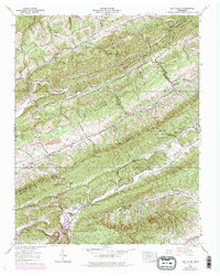
1939 Map of Lee Valley
USGS Topo · Published 1973About this map
Chestnut Ridge and Clinch Mountain dictate the deep longitudinal valleys of this East Tennessee landscape, where the Tennessee Valley Authority documented the rural fabric of the 1930s. The settlement at Lee Valley sits at a crossroads between Copper Ridge and the Big War Gap, serving as a central point for the surrounding hamlets of Luther, Klondike, and Young Town. The map reveals a high density of small family burial grounds and country churches that reflect the area's genealogical depth, including the McGinnis Cem and Spruce Pine Ch.
Find a feature on this map
54 named features on this map. Tap any name to fly to it.
Don’t see what you’re looking for? This feature index may not catch every label — zoom into the map to look around manually.
Map Details
Editions of this 1939 Lee Valley Map
3 editions found
Other maps of this area

1883 · Morristown
USGS Topo · 1:125,000

1887 · Jonesville
USGS Topo · 1:125,000

1891 · Jonesville
USGS Topo · 1:125,000

1893 · Morristown
USGS Topo · 1:125,000

1895 · Morristown
USGS Topo · 1:125,000

1932 · Hagan
USGS Topo · 1:62,500

1935 · Rogersville
USGS Topo · 1:48,000

1935 · Tate Springs
USGS Topo · 1:48,000

1935 · Kyles Ford
USGS Topo · 1:24,000

1935 · Lee Valley
USGS Topo · 1:24,000