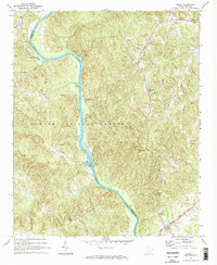
1969 Map of Leeds
USGS Topo · Published 1974About this map
The Broad River serves as the central artery and natural boundary between Union and Chester Counties in this late 1960s survey. Much of the landscape is dominated by the Sumter National Forest, where the terrain is punctuated by a network of local landmarks including the Leeds Lookout Tower and Leeds Campground. The river itself is a site of both industry and leisure, featuring the Neal Shoals Powerplant and the Woods Ferry Recreation Area. Small agrarian settlements and family nodes are evident through numerous country churches and cemeteries, such as Mount Olive Ch and Paradise Cem. In the northeast, the village of Wilksburg sits near the Pilgrim Sch, while the Seaboard Coast Line railroad skirts the southern edge through the community of Leeds. This map documents a quiet, wooded region defined by its river-bend topography and deep-rooted rural institutions.
Find a feature on this map
36 named features on this map. Tap any name to fly to it.
Don’t see what you’re looking for? This feature index may not catch every label — zoom into the map to look around manually.
Map Details
Editions of this 1969 Leeds Map
2 editions found
Other maps of this area

1907 · Sharon
USGS Topo · 1:62,500

1941 · Spartanburg
USGS Topo · 1:250,000

1953 · Spartanburg
USGS Topo · 1:250,000

1960 · Spartanburg
USGS Topo · 1:250,000

1963 · Spartanburg
USGS Topo · 1:250,000

1964 · Spartanburg
USGS Topo · 1:250,000
1969 · Carlisle
USGS Topo · 1:24,000

1969 · Kelton
USGS Topo · 1:24,000

1969 · Baton Rouge
USGS Topo · 1:24,000
1969 · Carlisle SE
USGS Topo · 1:24,000