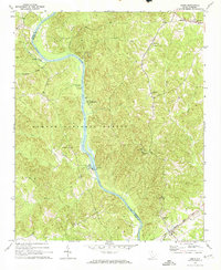
1969 Map of Leeds
USGS Topo · Published 1974About this map
The Broad River carves a deep boundary between Union Co and Chester Co, anchoring a landscape largely defined by the Sumter National Forest. This late-1960s survey documents a rural topography where social life centered on small congregations and cemeteries, such as Zion Pilgrim Ch and Mount Olive Cem. The terrain is deeply dissected by numerous tributaries including Browns Creek, Clarks Creek, and Brushy Fork, reflecting the heavy relief of the Piedmont. Transport and utility infrastructure are concentrated along the river corridor, featuring a Powerplant and the Woods Ferry Recreation Area. To the southeast, the Seaboard Coast Line railroad passes through the small community of Leeds, while the Leeds Lookout Tower stands as a sentinel over the timbered hills. This map captures the region before significant modern development, preserving the locations of family landmarks like Thomas Cem and the Pilgrim Sch.
Find a feature on this map
32 named features on this map. Tap any name to fly to it.
Don’t see what you’re looking for? This feature index may not catch every label — zoom into the map to look around manually.
Map Details
Editions of this 1969 Leeds Map
2 editions found
Other maps of this area

1907 · Sharon
USGS Topo · 1:62,500

1941 · Spartanburg
USGS Topo · 1:250,000

1953 · Spartanburg
USGS Topo · 1:250,000

1960 · Spartanburg
USGS Topo · 1:250,000

1963 · Spartanburg
USGS Topo · 1:250,000

1964 · Spartanburg
USGS Topo · 1:250,000
1969 · Carlisle
USGS Topo · 1:24,000

1969 · Kelton
USGS Topo · 1:24,000

1969 · Baton Rouge
USGS Topo · 1:24,000
1969 · Carlisle SE
USGS Topo · 1:24,000