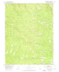
1951 Map of Leek Spring Hill
USGS Topo · Published 1974About this map
Eldorado National Forest defines this Sierra Nevada landscape, where the high ridges of the divide separate the watersheds of the Silver Fork American River and the Cosumnes River. Mapping based on 1948 photography and 1951 fieldwork reveals a terrain transition marked by steep canyons and named ridges like Mill Creek Ridge and Alder Ridge. Small settlements and named mountain camps such as Morrison, Pilliken, and Meiss are scattered along the primitive road network, illustrating the early 1950s footprint of forest management and high-country habitation. Significant natural landmarks include Iron Mtn, the prominent Leek Spring Hill, and isolated water sources like Buckskin Joe Spring and Olyer Spring. The network of watercourses, including North Fork, Middle Fork, and South Fork, highlights the complex drainage patterns feeding the region's river systems during this era of post-war topographical study.
Find a feature on this map
38 named features on this map. Tap any name to fly to it.
Don’t see what you’re looking for? This feature index may not catch every label — zoom into the map to look around manually.
Map Details
Editions of this 1951 Leek Spring Hill Map
3 editions found
Other maps of this area

1889 · Pyramid Peak
USGS Topo · 1:125,000

1891 · Pyramid Peak
USGS Topo · 1:125,000

1895 · Pyramid Peak
USGS Topo · 1:125,000

1896 · Pyramid Peak
USGS Topo · 1:125,000

1947 · Sacramento
USGS Topo · 1:250,000

1948 · Sacramento
USGS Topo · 1:250,000

1950 · Riverton
USGS Topo · 1:24,000
1951 · Stump Spring
USGS Topo · 1:24,000

1951 · Leek Spring Hill
USGS Topo · 1:24,000
1951 · Caldor
USGS Topo · 1:24,000