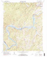
1966 Map of Leesville
USGS Topo · Published 1984About this map
Leesville Lake dominates the center of this 1960s landscape, where the Roanoke River is impounded at the Leesville Powerhouse Dam. The map documents a period of significant hydroelectric development and recreational transition for the region, illustrated by the various boat ramps and the Campground along the lake's branching fingers like Jasper Creek and Stony Creek. North of the water, the Norfolk and Western RR skirts the settlement of Leesville, passing beneath the shadows of King George Mtn.
Find a feature on this map
48 named features on this map. Tap any name to fly to it.
Don’t see what you’re looking for? This feature index may not catch every label — zoom into the map to look around manually.
Map Details
Editions of this 1966 Leesville Map
3 editions found
Other maps of this area

1890 · Roanoke
USGS Topo · 1:125,000

1891 · Roanoke
USGS Topo · 1:125,000

1892 · Lynchburg
USGS Topo · 1:125,000

1921 · Chatham
USGS Topo · 1:48,000

1922 · Callands
USGS Topo · 1:48,000

1923 · Chatham
USGS Topo · 1:62,500

1924 · Callands
USGS Topo · 1:62,500

1944 · Callands
USGS Topo · 1:62,500

1947 · Roanoke
USGS Topo · 1:250,000

1951 · Moneta
USGS Topo · 1:62,500