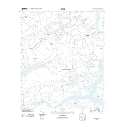
2011 Map of Legareville
USGS Topo · Published 2011About this map
Legareville and the southern reaches of Johns Island are defined by a complex network of coastal waterways including the Stono River and the Kiawah River. This 2011 survey documents a landscape of established island communities like Seven Oaks, Stafford Heights, and Fenwick Hills, where modern residential development meets older rural crossroads. Significant local landmarks such as the Johns Island Post Office and Johns Island Lookout Tower provide anchors for the community, while the presence of the Charleston Executive Airport and the W B Upshur Private Airport highlights the area's role in regional aviation. The map reveals a transition from these hubs to the marshy periphery, where names like Huskum Corner Cross Roads and Miller Hill hint at the island's long history of settlement. Tracing the courses of Abbapoola Creek and Bohicket Creek offers insights into the historical reliance on these tidal arteries for transportation and commerce long before the modern expansion of River Road.
Find a feature on this map
125 named features on this map. Tap any name to fly to it.
Don’t see what you’re looking for? This feature index may not catch every label — zoom into the map to look around manually.
Map Details
Editions of this 2011 Legareville Map
This is the sole edition of this map. No revisions or reprints were ever made.
Other maps of this area

1918 · Kiawah Island
USGS Topo · 1:21,120

1919 · Johns Island
USGS Topo · 1:21,120

1919 · Wadmelaw Island
USGS Topo · 1:62,500

1919 · Charleston
USGS Topo · 1:21,120

1919 · James Island
USGS Topo · 1:21,120

1919 · Legareville
USGS Topo · 1:21,120

1920 · Ravenels
USGS Topo · 1:62,500

1943 · Legareville
USGS Topo · 1:24,000

1943 · James Island
USGS Topo · 1:24,000

1943 · Kiawah Island
USGS Topo · 1:24,000