
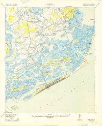
1943 Map of James Island
USGS Topo · Published 1943About this map
Sol Legare Island and the intricate marshlands of the James Island quadrangle appear here during the Second World War, showing a coastal landscape defined by tidal inlets and small agrarian settlements. The map illustrates the strategic and maritime importance of the area, featuring the Morris Island Coast Guard Station and the James Island Airport north of Seaside. Significant historical landmarks such as Secessionville and Payne Chapel are clearly marked, providing essential points of reference for genealogists and local historians. The transition from the rural interior of James Island to the burgeoning beachfront at Folly Beach is evident, connected by Kings Road and Stono Road. This survey, revised from 1941 aerial photography, captures the low-lying topography of Morris Island and Oak Island before extensive modern development altered the South Carolina shoreline.
Find a feature on this map
31 named features on this map. Tap any name to fly to it.
Don’t see what you’re looking for? This feature index may not catch every label — zoom into the map to look around manually.
Map Details
Editions of this 1943 James Island Map
2 editions found
Other maps of this area

1918 · Kiawah Island
USGS Topo · 1:21,120

1919 · Johns Island
USGS Topo · 1:21,120

1919 · The Jetties
USGS Topo · 1:21,120

1919 · Wadmelaw Island
USGS Topo · 1:62,500

1919 · Charleston
USGS Topo · 1:21,120

1919 · James Island
USGS Topo · 1:21,120

1919 · Fort Moultrie
USGS Topo · 1:21,120

1919 · Legareville
USGS Topo · 1:21,120

1920 · Ravenels
USGS Topo · 1:62,500

1943 · Fort Moultrie
USGS Topo · 1:24,000