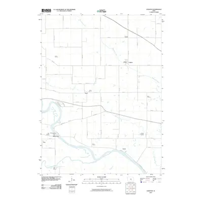
2010 Map of Leighton
USGS Topo · Published 2010About this map
The Des Moines River winds through the southwestern portion of this Mahaska County landscape, creating a fertile river valley defined by its seasonal floodplains and winding tributaries. The small settlement of Leighton serves as a local hub, featuring the Leighton Post Office and nearby Evergreen Cemetery, while smaller communities like Olivet and Bellefountain are spaced along the rural road network. The terrain is marked by significant hydrological features including Muchakinock Creek and Cedar Creek, which drain the agricultural uplands toward the river.
Find a feature on this map
48 named features on this map. Tap any name to fly to it.
Don’t see what you’re looking for? This feature index may not catch every label — zoom into the map to look around manually.
Map Details
Editions of this 2010 Leighton Map
This is the sole edition of this map. No revisions or reprints were ever made.
Other maps of this area

1910 · Pella
USGS Topo · 1:62,500

1912 · Pella
USGS Topo · 1:62,500

1929 · Albia
USGS Topo · 1:62,500

1954 · Des Moines
USGS Topo · 1:250,000

1956 · Des Moines
USGS Topo · 1:250,000

1957 · Des Moines
USGS Topo · 1:250,000

1968 · Oskaloosa
USGS Topo · 1:24,000

1968 · Eddyville
USGS Topo · 1:24,000

1969 · Des Moines
USGS Topo · 1:250,000
1980 · Leighton
USGS Topo · 1:24,000