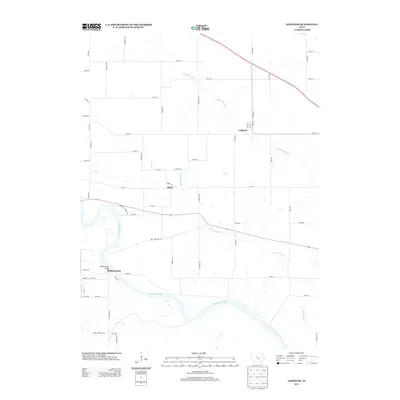
2013 Map of Leighton
USGS Topo · Published 2013About this map
The Des Moines River winds through the southern portion of this Mahaska County landscape, creating a wide riparian corridor punctuated by the crossing at Bellefountain Bridge. In this early 21st-century view, the small settlements of Leighton and Olivet anchor a grid of rural roads and section lines typical of the Iowa prairie. The hydrography of the region is defined by several significant tributaries, including Muchakinock Cr, Price Cr, and Saint Joseph Cr, which carve subtle drainage patterns across the agricultural uplands. Evidence of the area's geography and infrastructure is found in names like Carbon Trl, hinting at the coal-mining heritage common to this part of the Des Moines River valley, even as the surface appears dominated by modern transport routes and local roads like Market St and Barrow Ave.
Find a feature on this map
55 named features on this map. Tap any name to fly to it.
Don’t see what you’re looking for? This feature index may not catch every label — zoom into the map to look around manually.
Map Details
Editions of this 2013 Leighton Map
This is the sole edition of this map. No revisions or reprints were ever made.
Other maps of this area

1910 · Pella
USGS Topo · 1:62,500

1912 · Pella
USGS Topo · 1:62,500

1929 · Albia
USGS Topo · 1:62,500

1954 · Des Moines
USGS Topo · 1:250,000

1956 · Des Moines
USGS Topo · 1:250,000

1957 · Des Moines
USGS Topo · 1:250,000

1968 · Oskaloosa
USGS Topo · 1:24,000

1968 · Eddyville
USGS Topo · 1:24,000

1969 · Des Moines
USGS Topo · 1:250,000
1980 · Leighton
USGS Topo · 1:24,000