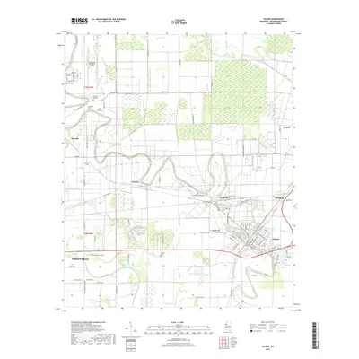
2018 Map of Leland
USGS Topo · Published 2018About this map
Greenville and Leland anchor this Washington County landscape, where the meandering course of Deer Creek dictates the historical development of the Delta's agricultural and transportation corridors. The map highlights the significant infrastructure of the Greenville Mid-Delta Airport in the northwest, serving as a hub for the region's aviation needs. Small settlements such as Stoneville, Metcalfe, and Magenta are scattered throughout the fertile plains, often clustered near the intricate network of bayous including Roper Bayou, Clark Bayou, and McCutcheon Bayou. Genealogists will find a high density of burial sites across the quadrangle, ranging from Greenlawn Memorial Gardens to smaller family or community plots like Christian Life Cem, Shamrock Cem, and Oakland Cem. The settlement pattern reflects a deeply rooted agrarian society, with numerous roads like Feather Farms Rd and Deer Creek Dr following the natural curves of the waterways and the straight lines of section boundaries.
Find a feature on this map
98 named features on this map. Tap any name to fly to it.
Don’t see what you’re looking for? This feature index may not catch every label — zoom into the map to look around manually.
Map Details
Editions of this 2018 Leland Map
This is the sole edition of this map. No revisions or reprints were ever made.
Other maps of this area

1933 · Lamont
USGS Topo · 1:62,500

1939 · Refuge
USGS Topo · 1:62,500

1939 · Lamont
USGS Topo · 1:62,500

1939 · Tralake
USGS Topo · 1:62,500

1939 · Choctaw
USGS Topo · 1:62,500

1953 · Greenwood
USGS Topo · 1:250,000

1956 · Greenwood
USGS Topo · 1:250,000
1967 · Tribbett
USGS Topo · 1:24,000

1967 · Arcola
USGS Topo · 1:24,000

1967 · Stringtown
USGS Topo · 1:24,000