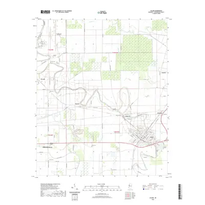
2020 Map of Leland
USGS Topo · Published 2020About this map
The delta landscape of Washington County is defined here by the winding course of Deer Creek, which snakes through the heart of the region between Greenville and Leland. This 2020 survey illustrates a complex agricultural and research environment, notably including the Stoneville area where the Experiment Station Rd suggests the long-standing agricultural science heritage of the Mississippi Delta. The map serves as a vital record for family historians, documenting numerous burial sites across the landscape such as Stoneville-Leland Cem, Oakland Cem, and Jake Cem Number 2.
Find a feature on this map
136 named features on this map. Tap any name to fly to it.
Don’t see what you’re looking for? This feature index may not catch every label — zoom into the map to look around manually.
Map Details
Editions of this 2020 Leland Map
This is the sole edition of this map. No revisions or reprints were ever made.
Other maps of this area

1933 · Lamont
USGS Topo · 1:62,500

1939 · Refuge
USGS Topo · 1:62,500

1939 · Lamont
USGS Topo · 1:62,500

1939 · Tralake
USGS Topo · 1:62,500

1939 · Choctaw
USGS Topo · 1:62,500

1953 · Greenwood
USGS Topo · 1:250,000

1956 · Greenwood
USGS Topo · 1:250,000
1967 · Tribbett
USGS Topo · 1:24,000

1967 · Arcola
USGS Topo · 1:24,000

1967 · Stringtown
USGS Topo · 1:24,000