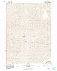
1991 Map of Lemay
USGS Topo · Published 1991About this map
Lucin Cutoff traverses the expansive Mud flats of Box Elder County, defining the industrial and logistical character of this arid Great Salt Lake desert landscape. This engineering feat, represented here as both a railroad and a roadway, cuts a straight line across the Newfoundland Evaporation Basin, a massive industrial feature used for salt production and water management. The tiny settlement of Lemay sits as a solitary point along this transit corridor, which serves as the primary human imprint in a region dominated by the Newfoundland Mountains and an extensive Aqueduct system. The map illustrates a landscape of extreme environmental management, where the infrastructure of the Great Basin’s mineral and rail economy interacts with the unique salt-encrusted terrain of the northern Utah desert.
Find a feature on this map
10 named features on this map. Tap any name to fly to it.
Don’t see what you’re looking for? This feature index may not catch every label — zoom into the map to look around manually.
Map Details
Editions of this 1991 Lemay Map
This is the sole edition of this map. No revisions or reprints were ever made.
Other maps of this area

1954 · Brigham City
USGS Topo · 1:250,000

1958 · Brigham City
USGS Topo · 1:250,000

1962 · Brigham City
USGS Topo · 1:250,000

1983 · Desert Peak
USGS Topo · 1:24,000

1983 · Lemay
USGS Topo · 1:24,000

1983 · Bovine SE
USGS Topo · 1:24,000

1983 · Terrace Mountain West
USGS Topo · 1:24,000

1983 · Terrace Mountain East
USGS Topo · 1:24,000

1983 · Sheep Mountain
USGS Topo · 1:24,000

1983 · Groome
USGS Topo · 1:24,000