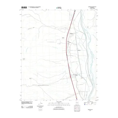
2011 Map of Lemitar
USGS Topo · Published 2011About this map
Lemitar and Polvadera anchor this mid-valley landscape along the Rio Grande in Socorro County. The settlement pattern follows the fertile river corridor, where an intricate network of irrigation and drainage infrastructure, including the San Acacia Drainage Canal, Alamillo Ditch, and Chamisal Drain, supports the local agriculture. Smaller named locales such as Chamizal, McNierney, and Limitar sit east of the modern highway corridor, while the Polvadera Post Office and Lemitar Post Office serve the principal communities. To the west, the terrain rises sharply toward Polvadera Mountain, cut by deep arroyos like San Lorenzo Arroyo and Cañoncito de la Cabras. For researchers, the presence of both the Polvadera Cemetery and Lemitar Cemetery offers specific points of genealogical interest within this traditional Rio Grande valley setting.
Find a feature on this map
48 named features on this map. Tap any name to fly to it.
Don’t see what you’re looking for? This feature index may not catch every label — zoom into the map to look around manually.
Map Details
Editions of this 2011 Lemitar Map
This is the sole edition of this map. No revisions or reprints were ever made.
Other maps of this area

1906 · Socorro
USGS Topo · 1:62,500

1916 · La Joya
USGS Topo · 1:125,000

1952 · San Anacia
USGS Topo · 1:24,000

1952 · La Joya
USGS Topo · 1:24,000

1954 · Socorro
USGS Topo · 1:250,000

1958 · Socorro
USGS Topo · 1:250,000

1959 · Loma De Las Canas
USGS Topo · 1:24,000

1959 · Socorro
USGS Topo · 1:24,000

1959 · Mesa Del Yeso
USGS Topo · 1:24,000

1959 · Lemitar
USGS Topo · 1:24,000