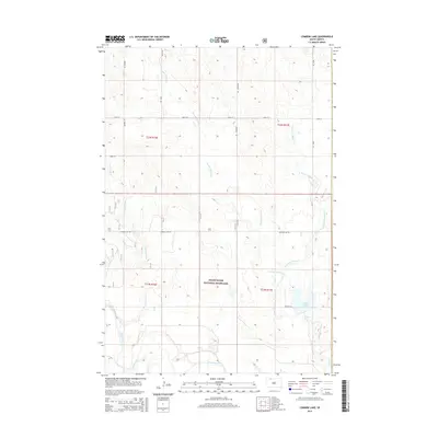
2015 Map of Lemmon Lake
USGS Topo · Published 2015About this map
Grand River National Grassland dominates this section of the Great Plains in Corson County, where the sprawling prairie meets a complex network of seasonal drainages. The landscape is defined by the winding course of the Grand River in the south and the namesake Lemmon Lake to the east. A grid of section roads, including Airport Rd, Lemmon Lake Rd, and Dewitt Rd, provides access across the open range and connects various parcels of public and private land. Numerous creeks like Thunder Hawk Cr, E Thunder Hawk Cr, and Dog Tooth Cr carve subtle coulees through the high plains, illustrating the hydrology of this northern South Dakota district before it reaches the Missouri River watershed.
Find a feature on this map
18 named features on this map. Tap any name to fly to it.
Don’t see what you’re looking for? This feature index may not catch every label — zoom into the map to look around manually.
Map Details
Editions of this 2015 Lemmon Lake Map
This is the sole edition of this map. No revisions or reprints were ever made.
Other maps of this area

1953 · McIntosh
USGS Topo · 1:250,000

1954 · Lemmon
USGS Topo · 1:250,000

1957 · Lemmon
USGS Topo · 1:250,000

1958 · McIntosh
USGS Topo · 1:250,000

1972 · Black Horse Butte NW
USGS Topo · 1:24,000

1972 · Thunder Hawk SW
USGS Topo · 1:24,000
1972 · Thunder Hawk
USGS Topo · 1:24,000

1974 · Lemmon
USGS Topo · 1:24,000
1974 · Lemmon NE
USGS Topo · 1:24,000

1980 · McIntosh
USGS Topo · 1:100,000