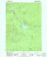
1986 Map of Lemolo Lake
USGS Topo · Published 1986About this map
Umpqua National Forest surrounds the vital hydroelectric infrastructure of the North Umpqua River in the mid-1980s. This survey details the complex water management system supporting the Lemolo Power Plant No 1, including the prominent Canal No 1 and a Penstock that bypasses the natural drop of Lemolo Falls. The landscape is defined by its volcanic origins and steep topography, featuring landmarks such as Dread and Terror Ridge, Elephant Mountain, and the expansive Pumice Flat. Recreational development is heavily concentrated around Lemolo Lake, where several campsites like the Poole Creek Campground and Bunker Hill Campground sit alongside numerous boat ramps. Further south, the map captures the transition into Mowich Park and the headwaters of the Clearwater River, illustrating a region dedicated to both energy production and wilderness preservation.
Find a feature on this map
42 named features on this map. Tap any name to fly to it.
Don’t see what you’re looking for? This feature index may not catch every label — zoom into the map to look around manually.
Map Details
Editions of this 1986 Lemolo Lake Map
This is the sole edition of this map. No revisions or reprints were ever made.
Other maps of this area

1917 · Diamond Lake
USGS Topo · 1:125,000

1956 · Toketee Falls
USGS Topo · 1:62,500

1956 · Diamond Lake
USGS Topo · 1:62,500

1956 · Summit Lake
USGS Topo · 1:62,500

1956 · Garwood Butte
USGS Topo · 1:62,500

1958 · Roseburg
USGS Topo · 1:250,000

1959 · Roseburg
USGS Topo · 1:250,000

1978 · Diamond Lake
USGS Topo · 1:100,000
1985 · Garwood Butte
USGS Topo · 1:24,000
1985 · Diamond Lake
USGS Topo · 1:24,000