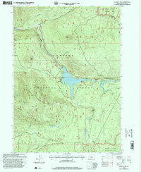
1998 Map of Lemolo Lake
USGS Topo · Published 2000About this map
Lemolo Lake serves as the central hub of this high-altitude landscape within the Umpqua National Forest, where the managed waters of the North Umpqua River meet significant hydroelectric infrastructure. The presence of Lemolo Power Plant No 1, Canal No 1, and a penstock near Lemolo Falls illustrates the mid-century engineering used to harness the river's descent. The surrounding terrain is defined by dramatic ridges and volcanic features, from the heights of Elephant Mountain and Kelsay Mountain to the broad expanse of Pumice Flat. Recreational development is evident in the cluster of sites along the shoreline, including Poole Creek Campground and Inlet Campground, while more remote reaches such as Toolbox Meadows and Mowich Park suggest the area's traditional uses for grazing and seasonal transit before the intensification of forest management.
Find a feature on this map
42 named features on this map. Tap any name to fly to it.
Don’t see what you’re looking for? This feature index may not catch every label — zoom into the map to look around manually.
Map Details
Editions of this 1998 Lemolo Lake Map
This is the sole edition of this map. No revisions or reprints were ever made.
Other maps of this area

1917 · Diamond Lake
USGS Topo · 1:125,000

1956 · Toketee Falls
USGS Topo · 1:62,500

1956 · Diamond Lake
USGS Topo · 1:62,500

1956 · Summit Lake
USGS Topo · 1:62,500

1956 · Garwood Butte
USGS Topo · 1:62,500

1958 · Roseburg
USGS Topo · 1:250,000

1959 · Roseburg
USGS Topo · 1:250,000

1978 · Diamond Lake
USGS Topo · 1:100,000
1985 · Garwood Butte
USGS Topo · 1:24,000
1985 · Diamond Lake
USGS Topo · 1:24,000