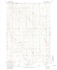
1962 Map of Lennox NW
USGS Topo · Published 1981About this map
The agrarian landscape of Turner and Lincoln counties unfolds across this survey, centered on the small village of Chancellor. The map reveals a highly structured rural society defined by its early township divisions, including Home, Delapre, Germantown, and Perry. The presence of several family-named and community institutions, such as Dirksen Sch, Schoffelman Sch, and Berens Sch, illustrates the density of the rural population before mid-century consolidation.
Find a feature on this map
25 named features on this map. Tap any name to fly to it.
Don’t see what you’re looking for? This feature index may not catch every label — zoom into the map to look around manually.
Map Details
Editions of this 1962 Lennox NW Map
2 editions found
Other maps of this area

1897 · Canton
USGS Topo · 1:125,000

1898 · Parker
USGS Topo · 1:125,000

1900 · Canton
USGS Topo · 1:125,000

1955 · Sioux Falls
USGS Topo · 1:250,000

1958 · Sioux Falls
USGS Topo · 1:250,000

1962 · Tea
USGS Topo · 1:24,000

1962 · Hartford South
USGS Topo · 1:24,000

1962 · Lennox NW
USGS Topo · 1:24,000

1962 · Sioux Falls West
USGS Topo · 1:24,000

1964 · Worthing
USGS Topo · 1:24,000