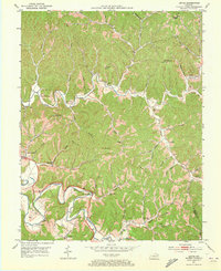
1951 Map of Lenox
USGS Topo · Published 1973About this map
Elk Fork and the Licking River anchor this mid-century survey of the Appalachian foothills in Morgan County. The landscape is defined by its deep hollows and narrow ridges, such as Bolin Ridge, where small rural communities like Lenox and Fannin took root. The concentration of local schools—including Lenox Sch, Banner Sch, and Lacy Creek Sch—points to a distributed network of small hill settlements that relied on these institutions as social hubs.
Find a feature on this map
61 named features on this map. Tap any name to fly to it.
Don’t see what you’re looking for? This feature index may not catch every label — zoom into the map to look around manually.
Map Details
Editions of this 1951 Lenox Map
2 editions found
Other maps of this area

1889 · Salyersville
USGS Topo · 1:125,000

1891 · Salyersville
USGS Topo · 1:125,000

1899 · Salyersville
USGS Topo · 1:125,000

1929 · Morehead
USGS Topo · 1:48,000

1935 · Morehead
USGS Topo · 1:62,500

1950 · Isonville
USGS Topo · 1:24,000

1950 · Sandy Hook
USGS Topo · 1:24,000

1950 · Lenox
USGS Topo · 1:24,000

1951 · Cannel City
USGS Topo · 1:24,000

1951 · White Oak
USGS Topo · 1:24,000