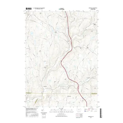
2016 Map of Lenoxville
USGS Topo · Published 2016About this map
Tunkhannock Creek and its many tributaries, such as Nine Partners Creek and Sterling Brook, carve a complex drainage pattern across this corner of Susquehanna County. The landscape is defined by its numerous glacial water bodies, including Loomis Lake, Horton Lake, and the marshy expanses of Tamarack Swamp. Settlement is distributed among small communities like Lenoxville and Glenwood, while the historic route of the Milford and Owego Turnpike Rd traces an older transportation corridor across the hills. Genealogists will find several burial grounds noted, including South Harford Cem and Maplewood Cem. The intersection of county lines in the south, where Susquehanna, Wyoming, and Lackawanna counties meet, provides a clear jurisdictional reference for local historians. High points like Hickory Ridge and Cobble Hill overlook a network of local thoroughfares such as Old Schoolhouse Rd and Orphan School Rd, reflecting the rural infrastructure of the early 21st century.
Find a feature on this map
95 named features on this map. Tap any name to fly to it.
Don’t see what you’re looking for? This feature index may not catch every label — zoom into the map to look around manually.
Map Details
Editions of this 2016 Lenoxville Map
This is the sole edition of this map. No revisions or reprints were ever made.
Other maps of this area

1892 · Dundaff
USGS Topo · 1:62,500

1932 · Susquehanna
USGS Topo · 1:62,500

1935 · Susquehanna
USGS Topo · 1:62,500

1943 · Montrose
USGS Topo · 1:62,500

1945 · Montrose
USGS Topo · 1:62,500

1946 · Tunkhannock
USGS Topo · 1:62,500

1946 · Dalton
USGS Topo · 1:24,000

1946 · Carbondale
USGS Topo · 1:24,000

1946 · Factoryville
USGS Topo · 1:24,000
1946 · Clifford
USGS Topo · 1:24,000
Featured Places
- Clifford Township, PA
- Lenox Township, PA
- Harford Township, PA
- Gibson Township, PA
- Marshbrook, Benton Township