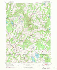
1946 Map of Clifford
USGS Topo · Published 1971About this map
The Elk Hill massive, featuring both North Knob and South Knob, dominates the central landscape of this Susquehanna County region. Just after World War II, the settlement pattern remained centered on historic hubs like Clifford and Dundaff, connected by winding roads and the traces of the Old Newburg Turnpike. This era shows a transition from traditional rural life to modern recreation, evidenced by the Elkview Country Club and Golf Course near Crystal Lake, alongside established family landmarks like the Burdick Cem and Lyons Street Cem.
Find a feature on this map
46 named features on this map. Tap any name to fly to it.
Don’t see what you’re looking for? This feature index may not catch every label — zoom into the map to look around manually.
Map Details
Editions of this 1946 Clifford Map
2 editions found
Other maps of this area

1892 · Honesdale
USGS Topo · 1:62,500

1892 · Dundaff
USGS Topo · 1:62,500

1926 · Starrucca
USGS Topo · 1:62,500

1930 · Starrucca
USGS Topo · 1:48,000

1932 · Susquehanna
USGS Topo · 1:62,500

1933 · Starrucca
USGS Topo · 1:62,500

1935 · Susquehanna
USGS Topo · 1:62,500

1943 · Honesdale
USGS Topo · 1:125,000

1946 · Dalton
USGS Topo · 1:24,000

1946 · Forest City
USGS Topo · 1:24,000