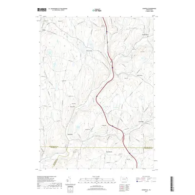
2019 Map of Lenoxville
USGS Topo · Published 2019About this map
Tunkhannock Creek and its East Branch carve through the landscape of southern Susquehanna County, defining the settlement patterns of towns like Lenoxville and Glenwood. This survey illustrates the intricate drainage network of the region, where numerous named water bodies such as Loomis Lake, Horton Lake, and Robinson Lake occupy the basins between prominent elevations. The terrain is marked by distinct summits, including Jeffers Hill, Gunn Hill, and Oak Knob, which have historically influenced the winding paths of local thoroughfares like the Milford and Owego Turnpike Rd.
Find a feature on this map
77 named features on this map. Tap any name to fly to it.
Don’t see what you’re looking for? This feature index may not catch every label — zoom into the map to look around manually.
Map Details
Editions of this 2019 Lenoxville Map
This is the sole edition of this map. No revisions or reprints were ever made.
Other maps of this area

1892 · Dundaff
USGS Topo · 1:62,500

1932 · Susquehanna
USGS Topo · 1:62,500

1935 · Susquehanna
USGS Topo · 1:62,500

1943 · Montrose
USGS Topo · 1:62,500

1945 · Montrose
USGS Topo · 1:62,500

1946 · Tunkhannock
USGS Topo · 1:62,500

1946 · Dalton
USGS Topo · 1:24,000

1946 · Carbondale
USGS Topo · 1:24,000

1946 · Factoryville
USGS Topo · 1:24,000
1946 · Clifford
USGS Topo · 1:24,000
Featured Places
- Clifford Township, PA
- Lenox Township, PA
- Harford Township, PA
- Gibson Township, PA
- Marshbrook, Benton Township