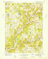
1949 Map of Lenoxville
USGS Topo · Published 1949About this map
Tunkhannock Creek carves a deep valley through this corner of Susquehanna County, anchoring a landscape defined by small rural hubs and post-war agricultural life. The settlement patterns of the late 1940s are visible in the clusters at Lenoxville, South Gibson, and West Lenox, where the West Lenox Ch served as a local anchor. The terrain is marked by family-named heights such as Gunn Hill and Carey Hill, while the lowland basins support numerous water bodies including Loomis Lake and Robinson Lake.
Find a feature on this map
63 named features on this map. Tap any name to fly to it.
Don’t see what you’re looking for? This feature index may not catch every label — zoom into the map to look around manually.
Map Details
Editions of this 1949 Lenoxville Map
This is the sole edition of this map. No revisions or reprints were ever made.
Other maps of this area

1892 · Dundaff
USGS Topo · 1:62,500

1932 · Susquehanna
USGS Topo · 1:62,500

1935 · Susquehanna
USGS Topo · 1:62,500

1943 · Montrose
USGS Topo · 1:62,500

1945 · Montrose
USGS Topo · 1:62,500

1946 · Tunkhannock
USGS Topo · 1:62,500

1946 · Dalton
USGS Topo · 1:24,000

1946 · Carbondale
USGS Topo · 1:24,000

1946 · Factoryville
USGS Topo · 1:24,000
1946 · Clifford
USGS Topo · 1:24,000