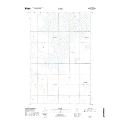
2019 Map of Leo
USGS Topo · Published 2019About this map
The settlement of Leo anchors this Roseau County landscape, which is defined by a grid-like system of rural roads and drainage infrastructure near the Canadian border. The area is heavily intersected by the State Ditch Number Seventy-two, a significant hydrographic feature that reflects the historic effort to manage the northern Minnesota wetlands for agriculture. A structured network of section lines and local routes, such as 120th Ave and Co Hwy 7, organizes the townships of t162n r44w and t161n r44w. The map details a transition between open fields and marshy terrain, showing how early 21st-century land use continues to follow the Public Land Survey System established over a century ago.
Find a feature on this map
22 named features on this map. Tap any name to fly to it.
Don’t see what you’re looking for? This feature index may not catch every label — zoom into the map to look around manually.
Map Details
Editions of this 2019 Leo Map
This is the sole edition of this map. No revisions or reprints were ever made.
Other maps of this area

1918 · Greenbush
USGS Topo · 1:62,500

1919 · Pelan
USGS Topo · 1:62,500

1919 · Badger
USGS Topo · 1:62,500

1930 · Juneberry
USGS Topo · 1:31,680

1932 · Juneberry
USGS Topo · 1:62,500

1952 · Thief River Falls
USGS Topo · 1:250,000

1956 · Thief River Falls
USGS Topo · 1:250,000

1957 · Thief River Falls
USGS Topo · 1:250,000

1957 · Pelan
USGS Topo · 1:62,500
1962 · Greenbush
USGS Topo · 1:24,000