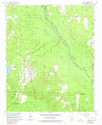
1965 Map of Leola
USGS Topo · Published 1980About this map
Leola serves as the primary hub of this 1960s landscape, positioned along the Chicago Rock Island and Pacific railroad as it cuts through the timberlands and river bottoms of central Arkansas. The town is flanked by smaller settlements like Thiel to the north and Carver to the west, with the winding Saline River and Moores Slough defining the low-lying eastern portion of the sheet. The map reveals a community deeply tied to its local geography, where multiple gravel pits and cemeteries like Taylor Cem and Crowder Cem mark the land. Further south, the rural character is emphasized by the presence of Hopewell Ch and the small community of Cooney. The dense network of creeks, including Brush Creek and Cox Creek, shows how water drainage dictated the early road patterns and settlement boundaries between Grant and Dallas counties.
Find a feature on this map
29 named features on this map. Tap any name to fly to it.
Don’t see what you’re looking for? This feature index may not catch every label — zoom into the map to look around manually.
Map Details
Editions of this 1965 Leola Map
3 editions found
Other maps of this area

1955 · Little Rock
USGS Topo · 1:250,000

1956 · Little Rock
USGS Topo · 1:250,000

1960 · Little Rock
USGS Topo · 1:250,000

1963 · Prattsville
USGS Topo · 1:24,000

1964 · Poyen
USGS Topo · 1:24,000

1964 · Little Rock
USGS Topo · 1:250,000

1964 · Sheridan
USGS Topo · 1:24,000

1964 · Bunn
USGS Topo · 1:24,000
1964 · Millerville
USGS Topo · 1:24,000
1965 · Leola
USGS Topo · 1:24,000