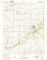
1963 Map of Leon
USGS Topo · Published 1979About this map
Leon serves as the central hub of this Kansas landscape, situated where the St Louis-San Francisco railroad crosses the Little Walnut River. The region's economy in the early 1960s is clearly defined by an extensive patchwork of energy extraction, with the Leon Oil Field, El Dorado Oil Field, and Bloomington Oil Field dominating the township. These fields are marked by numerous oil wells and a complex network of pipelines that navigate the river valleys and prairie uplands.
Find a feature on this map
31 named features on this map. Tap any name to fly to it.
Don’t see what you’re looking for? This feature index may not catch every label — zoom into the map to look around manually.
Map Details
Editions of this 1963 Leon Map
3 editions found
Other maps of this area

1888 · Eldorado
USGS Topo · 1:125,000

1955 · Wichita
USGS Topo · 1:250,000

1958 · Wichita
USGS Topo · 1:250,000

1961 · Augusta
USGS Topo · 1:24,000

1961 · Pontiac
USGS Topo · 1:24,000

1961 · El Dorado
USGS Topo · 1:24,000

1961 · Gordon
USGS Topo · 1:24,000
1961 · El Dorado SW
USGS Topo · 1:24,000

1963 · Leon
USGS Topo · 1:24,000

1964 · Augusta SE
USGS Topo · 1:24,000